Hi - I' ve been trying to find a way to convert the Landsat ToA (top of atmosphere) reflectance to Surface reflectance but I haven't found an algorithm for this.
I am doing a temporal analysis for a lake with Landsat dataset, applying NDVI and FAI (floating vegetation index) indices. Would be correct to calculate the NDVI with the ToA reflectance or surface reflectance should be better used, even though there is a possibility that more error could be induced than corrected?
Any ideas would be appreciated!
Surface reflectance algorithm for Landsat dataset and calculation of indices
-
OB.DAAC - SeanBailey
- User Services

- Posts: 1470
- Joined: Wed Sep 18, 2019 6:15 pm America/New_York
- Been thanked: 5 times
Surface reflectance algorithm for Landsat dataset and calculation of indices
The l2gen code distributed with SeaDAS is capable of processing Landsat 8 data and outputting surface reflectance (
It can also output NDVI as a product. FAI, no, but that algorithm is pretty simple :)
Sean
rhos, Rayliehgh subtracted TOA).It can also output NDVI as a product. FAI, no, but that algorithm is pretty simple :)
Sean
Surface reflectance algorithm for Landsat dataset and calculation of indices
Hello Sean,
Thanks, I will have a look at the l2gen code.
I am using Landsat 5, 7 and 8 and I have already done the conversion from DN to Radiance and from Radiance to ToA reflectance with the formulas I have found in the Dat User's Handbooks from each satellite. If you have used already the l2gen, are you aware if it is possible to process all the datasets (from Landsat 5, 7 ,8) with l2gen code?
Do I have to omit some of the steps I have already done?
By rhos you mean the Rayleigh corrected top of atmosphere reflectance (Rrc=surface reflectance), right?
Something more, for the FAI index calculation, which SWIR band should be used SWIR1 or SWIR2 and why?
-
OB.DAAC - SeanBailey
- User Services
- Posts: 1470
- Joined: Wed Sep 18, 2019 6:15 pm America/New_York
- Been thanked: 5 times
Surface reflectance algorithm for Landsat dataset and calculation of indices
The l2gen code *does* have support for Landsat 5 & 7 - but it may not be fully baked, so we've not really advertised it. In fact, it requires a bit of manual intervention to get the required data files installed. Landsat 8 is fully supported. The code starts from the Level 1 files. If you try it out and find it successful for L8, I can point you at how to get L5 and L7 working...
The Hu et al. FAI was defined for MODIS and used the 1240nm SWIR channel, so SWIR1 is probably the best choice - although it may not really matter.
Sean
The Hu et al. FAI was defined for MODIS and used the 1240nm SWIR channel, so SWIR1 is probably the best choice - although it may not really matter.
Sean
Surface reflectance algorithm for Landsat dataset and calculation of indices
Hello Sean,
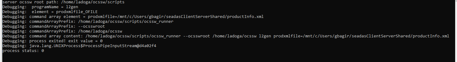
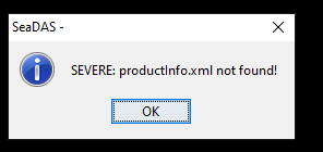
I installed SeaDAS 7.5.3 and OCSSW server and tried to initialize l2gen module after installing oli process, but something is wrong.
I am getting a message that productInfo.xml cannot be found. Do you have any idea why this file was not included in the installation process?
https://www.dropbox.com/s/n9kplfyzmeela4e/SeaDAS_Error.JPG?dl=0
https://www.dropbox.com/s/n1zzxpch6jmsai7/ocssw_l2gen_error.JPG?dl=0
Thanks
Surface reflectance algorithm for Landsat dataset and calculation of indices
A previous post describes some permission problems.
From the images, it appears that you have installed the ocssw software as the "root" user using the default install directory ("
From the images, it appears that you have installed the ocssw software as the "root" user using the default install directory ("
/root/ocssw"). Recent linux distros have put restrictions on what a "root" user is allowed to do, so your installation may not work as expected. The "root" user can, however, change system configuration files despite the restrictions, so should only be used for administrative tasks. SeaDAS OCSSW is designed to be run by a regular user, and does not have the level of scrutiny that administrative tools receive.Surface reflectance algorithm for Landsat dataset and calculation of indices
Hello all,
I have problem initializing l2gen to process Landsat Oli. I get the error SEVERE: productInfo.xml not found!
The same issue was reported by Keco on 2019-09-29.
I followed the suggestions by gnwii but I still have the same error.
All file and folders permissions are ok but I cannot figure out what is the problem.
I will be very grateful for your suggestions and help to resolve this issue.
I have attached png file of the error and output from running the l2gen.
I have installed SeaDAS 7.5.3 on Ubuntu 16.04 LTS using Windows 10, 64 bit, WSL.
I installed the ocssw processors from GUI.
If you need some additional information, please feel free to ask.
Best regards
Augustineattachment 1
attachment 2
Surface reflectance algorithm for Landsat dataset and calculation of indices
This should be a new topic, so others can find it. I have started a "Windows WSL l2gen initialization failure" topic under SeaDAS 7.
You should provide more details of your configuration: post the server config file and the new section of your seadas config file. Are you using WSL2? Which Java runtime are you using?
You should provide more details of your configuration: post the server config file and the new section of your seadas config file. Are you using WSL2? Which Java runtime are you using?