Page 1 of 1
MISR stacked-block format
Posted: Tue Jan 07, 2020 2:17 pm America/New_York
by EarthdataForumContributor
What is stacked-block format? Which format should I choose?
Re: MISR stacked-block format
Posted: Tue Jan 07, 2020 2:18 pm America/New_York
by asdc_user_services
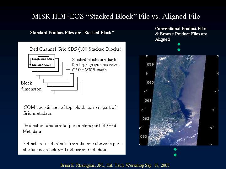
Stacked-block HDF-EOS format is a MISR specific extension to the HDF-EOS library that is only used by MISR and is not widely supported by third party data analysis tools. Tools which support HDF-EOS or HDF can usually import stacked-block data to a limited extent. Two problems commonly encountered are: 1) piecing together the MISR blocks so they are aligned correctly with respect to each other; and 2) geolocating the MISR data in a map context. Many tools do not support geolocation of the stacked-block HDF-EOS format. A detailed discussion of the stacked-block HDF-EOS format including instructions on how to write software to geolocate MISR data are discussed in Appendix A of the Data Product Specifications Document.
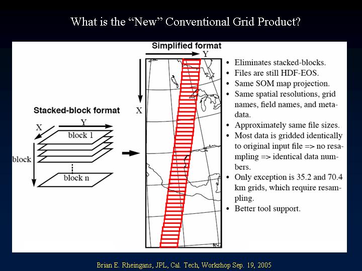
The conventional HDF-EOS format is an alternative format that uses only common HDF-EOS elements, specifically excluding use of the stacked-block extensions. As a result, the conventional HDF-EOS format should be easily imported into any tools that support generic HDF-EOS. In practice however, there are still many tools which have only limited support for HDF-EOS. Conversion to conventional HDF-EOS format attempts to reproduce the data content of the original products, only changing the data format. However, there are some notable differences in the data content for some fields which are discussed below. Geolocation is based on the standard parameters used by the General Cartographic Transformation Package (GCTP) library which is distributed with the HDF-EOS library. Data are map projected using the same Space Oblique Mercator (SOM) projection as the original products.
The choice of format largely depends on the tools you are using. Some MISR specific tools, such as misr_view, only support stacked-block format. Tools with only generic support for HDF or HDF-EOS, will be able to display stacked-block data a block-at-time, but will not automatically stitch blocks together with the proper alignment, and will not provide geolocation information.
- If you are using MISR-specific tools such as misr_view or the MISR ENVI Tools, you should use the stacked-block format.
- If you are using generic HDF or HDF-EOS tools, you should use the conventional format.

- faq_b4.jpg (61.18 KiB) Viewed 222 times
- faq_b7.jpg (59.2 KiB) Viewed 221 times
- faq_b6.jpg (59.13 KiB) Viewed 222 times