Yes, this is what the daily OCO-2 data look like, a series of measurements along the satellite's observational ground track. This is the highest resolution data available. The satellite track is not in the same place each day, and near-global coverage repeats every 16 days, so your location of interest may be under or near a satellite overpass on some days. Are measurements separated in time useful to you?
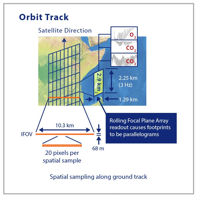
The spatial resolution (footprint) of the measurement is indeed 2.25 x 1.29 km.
The alternative is to use the OCO-2 Level 3 data, available at daily resolution, but reduced spatial resolution. This dataset currently ends in 2022, but I would expect this to be updated. I do not have information on when an update would be expected. https://disc.gsfc.nasa.gov/datasets/OCO2_GEOS_L3CO2_DAY_10r/summary?keywords=OCO-2%20level%203
You can export the data from Panoply in CSV format; we have a How-To document that describes how to convert this output to a lat-lon-data value format using Excel. This would work for the Level 2 data, thought many of the data values would be null (or zero).
How to Create Maps with Giovanni and Panoply: Creating Quantified ASCII Text Map Output with Giovanni, Panoply, and Excel
OCO-2 spatial resolution
-
GES DISC - jimacker
- User Services

- Posts: 324
- Joined: Mon Sep 30, 2019 1:57 pm America/New_York
- Has thanked: 2 times
- Been thanked: 4 times
Re: OCO-2 spatial resolution
l tried merge daily data for 2024 January. l noticed data is not cover full area.
Is there way merge daily nc data for monthly and then display?
Also it has 10 km differ between points. maybe l download wrong data. l am not sure. just click on file which shared on attach file.
Additionally, l select my study area, but data is not clipped by selected polygon.
Is there way merge daily nc data for monthly and then display?
Also it has 10 km differ between points. maybe l download wrong data. l am not sure. just click on file which shared on attach file.
Additionally, l select my study area, but data is not clipped by selected polygon.
- Attachments
-
- oco-2 data.PNG (127.96 KiB) Not viewed yet
Last edited by bext_la on Mon May 20, 2024 6:18 pm America/New_York, edited 1 time in total.
Re: OCO-2 spatial resolution
Spatial: 2.25 km x 1.29 km
May anyone explain what does mean this? So Data is points and each points are within 10 km of each other.
Second question how may l get data for monthly or yearly?
May anyone explain what does mean this? So Data is points and each points are within 10 km of each other.
Second question how may l get data for monthly or yearly?
-
GES DISC - jimacker
- User Services
- Posts: 324
- Joined: Mon Sep 30, 2019 1:57 pm America/New_York
- Has thanked: 2 times
- Been thanked: 4 times
Re: OCO-2 spatial resolution
The dimensions refer to the size of the "footprint" of the measurement on the Earth's surface. So you can imagine that the data is collected for a rectangular column of air with the dimensions of 2.25 x 1.29 km. Each measurement is made at nadir from the satellite's position.
This diagram may help you visualize how the data is acquired. https://ocov2.jpl.nasa.gov/media/images/orbittrack_2016.original.jpg
The Level 3 data is provided as daily or monthly data: this is the link to the monthly data. https://disc.gsfc.nasa.gov/datasets/OCO2_GEOS_L3CO2_MONTH_10r/summary There is no annual data product available at this time.
Re: OCO-2 spatial resolution
Thanks for additional attachments.
Monthly data till 2022. l download daily (31 days for 2024 jan), visualise all in panoply and export all points to excel. Then visualise in Arcgis Pro, But most of area are not covered. And point has 10 km distance each-other.
Do you have 2024 data for any month or 2023? if have, may you share here?
-
GES DISC - jimacker
- User Services
- Posts: 324
- Joined: Mon Sep 30, 2019 1:57 pm America/New_York
- Has thanked: 2 times
- Been thanked: 4 times
Re: OCO-2 spatial resolution
Are you creating the averages with Level 2 data or Level 3 data? The Level 2 data is available through April 1, 2024.
Re: OCO-2 spatial resolution
https://disc.gsfc.nasa.gov/datasets/OCO2_L2_Lite_FP_11.1r/summary?keywords=OCO-2
l used level 2 data. level 3 is not available current year and also 2023.
where did you get that Level 2 data is available through April 1, 2024?
l used level 2 data. level 3 is not available current year and also 2023.
where did you get that Level 2 data is available through April 1, 2024?
Re: OCO-2 spatial resolution
GES DISC - mgreene wrote:
> In response to<
> Re: OCO-2 spatial resolution
> by bext_la » Wed Apr 03, 2024 9:56 am America/New_York
>
> OCO-2 orbits the world every 16 days and collects data in its orbit path,
> which is what you show in your first attachment "OCO-2-1". If you
> are wanting to see "gap-filled" data, I'd like to direct you to
> the OCO2_GEOS_L3CO2_MONTH_10r and OCO2_GEOS_L3CO2_DAY_10r products which
> are assimilated products aggregated by monthly and daily averages,
> respectively. These products are compatible with our online web tool called
> Giovanni
> (https://disc.gsfc.nasa.gov/information/tools?keywords=Giovanni&title=Giovanni)
> which allows for easily customizable imagery, including selecting area by
> country as you mentioned. I think this dataset and Giovanni will be
> helpful. Please see my screenshots which show how I selected the data and
> North America, as well as the image output.
>
> [https://discette.gsfc.nasa.gov/tt/attachment.cgi?id=8870]
>
> [https://discette.gsfc.nasa.gov/tt/attachment.cgi?id=8871][/https://discette.gsfc.nasa.gov/tt/attachment.cgi?id=8871]
Mgreene, could you download current year data and visualise all your area?
-
GES DISC - jimacker
- User Services
- Posts: 324
- Joined: Mon Sep 30, 2019 1:57 pm America/New_York
- Has thanked: 2 times
- Been thanked: 4 times
Re: OCO-2 spatial resolution
Refer to the "Temporal Coverage" field in the Dataset Landing Page at the link you cited, under the "Product Summary" tab.l used level 2 data. level 3 is not available current year and also 2023.
where did you get that Level 2 data is available through April 1, 2024?
Re: OCO-2 spatial resolution
Yes, data in level 2 available from 2014 to now.
Problem is that l could not data for whole area. as l told, l collected 31 day data and only cover less area (about 10 percent).
could you download data and visualise, if yes, may you share screenshot or data?
Problem is that l could not data for whole area. as l told, l collected 31 day data and only cover less area (about 10 percent).
could you download data and visualise, if yes, may you share screenshot or data?