Welcome to the Earthdata Forum! Here, the scientific user community and subject matter experts from NASA Distributed Active Archive Centers (DAACs), and other contributors, discuss research needs, data, and data applications.
by junzhao » Thu Nov 13, 2014 1:45 am America/New_York
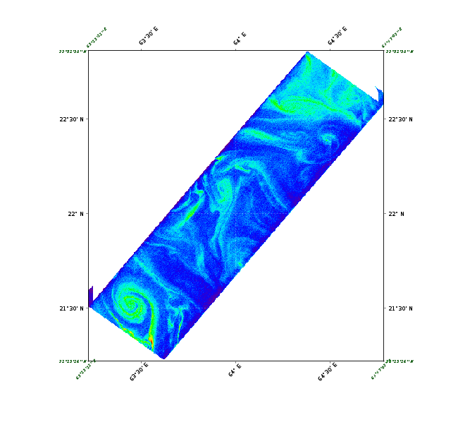
Hi there, I posted the same question in 'SeaDAS 7 - General questions'. But I haven't got any responses. Maybe I posted in the wrong place. So I post it again. A hico level 2 product was projected in Seadas V7.1. However, there are some problems at the right and left corners. An representative image is attached here. Please advise. Thanks. Jun
I had a look at the HICO scene you refer to and find the geolocation information has no unexpected corner anomalies. I am attaching a 3-band image I made from the data without using SeaDAS. We'll need to investigate further.
In the mean time, can you post the exact steps you used to make your image?
By default, the Reprojection tool uses a nearest neighbor resampling approach. It offers two others: bilinear and bicubic. If you select the bicubic approach, the reprojected image does not have these 'wing-like' artifacts. I will contact our BEAM partners (who developed the reprojection tool) to see if they can identify why these artifacts occur with the nearest neighbor (and apparently the bilinear) option
by junzhao » Sun Nov 16, 2014 12:20 am America/New_York
Hi Sean, Thanks. You're right. If the 'bicubic' resampling method is selected, the artifact is gone. @Norman. The step I used was Processing -> Reproject. The output format was set as 'GeoTIFF'. The other parameters are as default. According to Sean's reply, everything is fine now. Thanks again. Jun
Yes, using GPT (the Graph Processing Tool). We're still working on a decent tutorial for this, however, there are several posts on this forum with examples. There is also an overview presentation on the subject.