How to configure the coordinates/projection of MODIS L1B data?
Posted: Wed Aug 15, 2018 11:13 am America/New_York
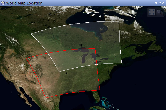
With MODIS Aqua L1 hdf file download from the Oceancolor website (MYD01.A20*.hdf), I ran GEO and L1A/B processing, using `/run/scripts/modis_GEO.py`, `/run/scripts/modis_L1A_extract.py`, `/run/scripts/modis_L1B.py` in the SEADAS software.But I notice in the created L1B data, some images have correct coordinates, some not. All of them have the same projection description as 'WGS84(DD)', see here:
[URL://drive.google.com/file/d/1QsEof76Co0fZiB9hWnELG79rB5ekCigT/view?usp=sharing ]. The correct image projection for some days (A2017264.1845.061.2018163172118): [URL: //drive.google.com/file/d/1X2SifjxxM39F8bZHz5QT7Ebn0pVlErYP/view?usp=sharing ]the incorrect image projection for some other day, with the same projection description (A2017265.1925.061.2018163172254): [URL: //drive.google.com/file/d/1Y3cV9fNbgZ3iw3SEeFvD5D4KfjonW90k/view?usp=sharing ] What I did wrong?
[URL://drive.google.com/file/d/1QsEof76Co0fZiB9hWnELG79rB5ekCigT/view?usp=sharing ]. The correct image projection for some days (A2017264.1845.061.2018163172118): [URL: //drive.google.com/file/d/1X2SifjxxM39F8bZHz5QT7Ebn0pVlErYP/view?usp=sharing ]the incorrect image projection for some other day, with the same projection description (A2017265.1925.061.2018163172254): [URL: //drive.google.com/file/d/1Y3cV9fNbgZ3iw3SEeFvD5D4KfjonW90k/view?usp=sharing ] What I did wrong?