
MODIS reflectance imagery that corresponds to the active fire detections, can be viewed in FIRMS Global, FIRMS US/Canada and Worldview.
What does a MODIS active fire detection mean on the ground?
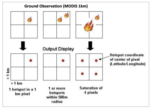
Satellites take a ‘snapshot’ of events as they pass over earth. Each hotspot/active fire detection represents the center of a 1 km (approx.) pixel flagged as containing one or more fires or other thermal anomalies (such as volcanoes). The “location” is the center point of the pixel (not necessarily the coordinates of the actual fire). The actual pixel size varies with the scan and track (see: What does scan and track mean?). The fire is often less than 1 km in size (see: What size fires can be detected?). We are not able to determine the exact fire size; what we do know is that at least one fire is located within that 1 km pixel. Sometimes you will see several active fires in a line. This generally represents a fire front.
Are there any missing MODIS fire data?
Terra was launched 18 December 1999 and Aqua was launched 4 May 2002. High quality active fire observations are available from the Terra satellite starting November 2000 and from the Aqua satellite starting 4 July 2002 onwards.
In the fire data archive, there are several days where data were not collected and days with lower than usual fire counts due to reasons such as sensor outage. These include, but are not limited to: 15 April 2001, 15 June to 3 July 2001, and 19 to 28 March 2002.
What does scan and track mean?
Scan and Track values are included in the attributes (see: What are the attributes / fields of the active fire data?). The scan value represents the spatial-resolution in the East-West direction of the scan and the track value represents the North-South spatial resolution of the scan. It should be noted that the pixel size is not always 1 km across the scan track. The pixels at the “Eastern” and the “Western” edges of the scan are bigger than 1 km. It is 1 km only along the nadir (exact vertical from the satellite). Thus, the values shown for scan and track represent the actual spatial resolution of the scanned pixel.
What is the brightness temperature?
The brightness temperature of a fire pixel is measured (in Kelvin) using the MODIS channels 21/22 and channel 31. Brightness temperature is actually a measure of the photons at a particular wavelength received by the spacecraft, but presented in units of temperature.
Where can I get the MODIS burned area product?
MODIS Active Fire & Burned Area Products web site and the MODIS Burned Area User Guide (Updated December 2020) and the MODIS Collection 6 and 6.1 Active Fire Product User Guide.
What size fires can be detected?
In any given scene the minimum detectable fire size is a function of many different variables (scan angle, biome, Sun position, land surface temperature, cloud cover, amount of smoke and wind direction, etc.), so the precise value will vary slightly with these conditions. MODIS routinely detects both flaming and smoldering fires 1000 m2 in size. Under very good observing conditions (e.g., near nadir, little or no smoke, relatively homogeneous land surface, etc.) flaming fires one tenth this size can be detected. Under pristine (and extremely rare) observing conditions even smaller flaming fires 50 m2 can be detected. It is not recommended to estimate burned area from the active fire data, see: Can I estimate burned area using the active fire data?.
Unlike most contextual fire detection algorithms designed for satellite sensors that were never intended for fire monitoring (e.g., AVHRR, VIIRS, ATSR), there is no upper limit to the largest and/or hottest fire that can be detected with MODIS.
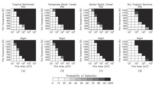
The diagram shows the day and night relationship of fire size and fire temperature, in different biomes, to the probability of being detected by MODIS (Giglio, et al. (2003)).
What validation of the MODIS active fire products has been performed?
Validation of the Terra MODIS Fire Product has primarily been performed using coincident observations from the Advanced Spaceborne Thermal Emission and Reflection Radiometer (ASTER); see the MODIS Land Team Validation page, and publications by Csiszar, et al. (2006) and two publications from Morisette, et al. (2005) for details. A very brief discussion of the general validation procedure, with some preliminary results, can be found in the Justice, et al. (2002) publication.
Where can I get more information on the MODIS Fire Products?
For more information on the active fire product and other MODIS fire products, please refer to the papers by Louis Giglio found here as well as the MODIS Active Fire Burned Area Products website and the MODIS Burned Area User Guide (Updated December 2020) and the MODIS Collection 6 Active Fire Product User Guide (Updated December 2020).