
NASA EOSDIS defines real-time (RT) data as data that are available to the end user within one hour of the satellite fly-over (see What is Data Latency? and What time does the satellite pass over my area?). Ultra real-time (URT) data are available much quicker—within minutes. Within FIRMS, the URT data are available within a minute of satellite overpass for select direct readout stations in the U.S. and Canada.
What is "direct broadcast"?
Direct broadcast, in addition to storing collected observation data for later download at designated intervals, some satellites have the capability to immediately broadcast this raw data to the ground. This is known as direct broadcast. As Earth is observed by the satellite, the data are formatted and transmitted to any user below with an antenna and other necessary equipment to receive and process the data. The Terra, Aqua, Suomi NPP, and NOAA-20 satellites all have direct broadcast capability.
What is "direct readout"?
The acquisition of freely transmitted direct broadcast satellite data by users with compatible ground receiving equipment is known as direct readout. Data can be collected by direct readout ground stations while they are in direct line of sight to satellites while they are visible above the horizon.
Are there particular differences between URT data, RT data and NRT data?
Ultra Real-Time (URT), Real-Time (RT), and Near Real-Time (NRT) data are all relative forms of low-latency data products made available more quickly than standard processing to support environmental monitoring, response to hazard/disaster events, etc.
NRT data processing frameworks, such as NASA LANCE, leverage operational Level 0 global data streams for several NASA missions and provide Level 2 products within 1-3 hours of satellite overpass. RT and URT data are predicated on the use of raw satellite data collected via direct readout ground stations. These ground stations are operated by various agencies and institutions, located around the globe and provide regional coverage. Ground stations typically process raw direct readout data to Level 0 to Level 1 to Level 2 data 30-60 minutes over satellite overpass and are considered RT data. Recently developed data processing technologies can now process direct readout data from Level 0 to Level 2 data products within 1 minute of satellite observation and are considered URT data.
How are URT active fire detection data integrated and used with NRT active fire detection data in FIRMS?
URT active fire detection data provided by select ground stations are integrated into FIRMS fire maps, KMZs and web map services within minutes of satellite observation. NRT active fire detection data replace the URT data in FIRMS mapping and data products and services as they become available 1-3 hours later. This integration of the data is seamless and not noticeable to the user unless there is a temporary anomaly occurring in either data source (e.g., a gap or artifact in the URT direct readout data stream).
How do I identify the NRT, RT and URT data?
FIRMS Fire Map and Map Services: To view the NRT, RT, and URT data in the FIRMS fire map, select the "Time Based" option in the FIRMS menu on the right. This symbolizes the active fire detections by time since detection. Both RT and URT data will display in the <1 hour category while NRT data will display in the 1-3 hour category or later categories. You can also click on individual active fire detection locations to bring up the attributes table; column X lists whether it is NRT, RT or URT data. The RT and URT fires will have a “Version” value (e.g., 2.0) followed by “RT” or “URT”. NRT fires will have a Version” value followed by “NRT.”
FIRMS KMZs: "Active fire detection footprint and centroid" KMZs symbolize active fire detection by time since detection. Time since detection KMZs symbolizes the active fire detections by time since detection. Both RT and URT data will display in the <1 hour category while NRT data will display in the 1-3 hour category or later categories. RT and URT data are not distinguished in the KMZ attributes.
Are URT data provided for all FIRMS products?
So far, URT active fire detection data are available in FIRMS interactive maps, KMZs, and web services for most of the conterminous U.S. plus S Canada and N Mexico.
Are URT data provided globally?
URT data are currently provided by four (4) select direct readout ground stations—one in Mayaguez, PR (red) and Hampton, VA (black) and two in Madison, WI (blue) (see graphic below). Each ground station can receive direct readout data when satellite orbits intersect their respective station masks. Additional United States ground stations will continue to be integrated with the objective of providing URT coverage for the U.S., Canada, and Central America. Integration of ground stations elsewhere on the globe will be evaluated and determined at a later date.
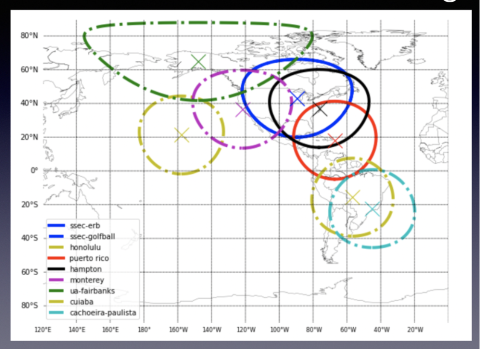
Current (solid lines) and Planned (dotted lines) Coverage of Ultra Real-Time and Real-Time Active Fire Data
What is the objective of providing URT data?
What is the objective of providing URT data?
Remote sensing observations and derived science products provide a "snapshot" of conditions at the time of satellite observation and are used to assess the situation and inform decisions. Consequently, the value of satellite data used for operational detection and monitoring of wildfires and other hazard/disaster events is inversely proportional to their latency. In other words, the value of the data typically increases with decreasing latency in data availability since satellite observation.