
The Landsat Fire and Thermal Anomalies (LFTA) product is predicated on previous NASA-sponsored research to develop an active fire detection algorithm for the Advanced Spaceborne Thermal Emission and Reflection Radiometer (ASTER) aboard Terra. ASTER multispectral imagery and derived active fire detection data have been routinely used over the past two decades to validate active fire products from MODIS and geostationary sensors. The LFTA product was added to FIRMS in August 2022. Developed under the auspices of the NASA Applied Sciences Wildland Fire Program, the product is based on multispectral imagery acquired by the Operational Land Imager (OLI) sensor aboard the Landsat 8 and Landsat 9 satellites. The 30 m active fire detection data has 1,000 times and 160 times finer spatial resolution than the 1 km MODIS and 375 m VIIRS active fire detections, respectively. However, unlike MODIS and VIIRS, Landsat does not provide comprehensive global coverage on a daily basis. Each Landsat satellite typically images the same location on Earth every 16 days, but provides spatially explicit data and detail of observable fire activity at the time of the satellite overpass. These data augment fire management capabilities when available and can potentially enable applications at tactical scales.
The LFTA product is generated from all daytime OLI acquisitions and currently provided for most of North America (CONUS, southern Canada, and northern Mexico). Increased geographic coverage for the product is under consideration and will be investigated in the near future. Targeted nighttime OLI data collection for most of North America is also possible (OLI data are collected by request at nighttime), potentially increasing the opportunity for more frequent observations for selected geographic areas of heightened wildfire activity, but opportunities for nighttime observations are much more limited due to several factors.
What is the temporal frequency of Landsat observations and derived active fire data?
The OLI sensor aboard the Landsat 8 and Landsat 9 satellites each image the entire Earth every 16 days at the mid latitudes. The respective orbits of the two satellites are 8 days out of phase so when considered collectively, the entire planet is imaged at least every 8 days. Active fire detection data are derived from multispectral imagery acquired by OLI and provided daily for each of the scheduled WRS-2 paths imaged by Landsat 8 and 9 on a given date. Please consult the Landsat 8 and Landsat 9 orbit tracks on the FIRMS fire maps to visualize the time of Landsat observations for a selected date (as depicted below; please see How to View Satellite Orbit Tracks in the FIRMS FAQs). Additional active fire detection data from tasked nighttime Landsat OLI observations are possible, but not routinely conducted.
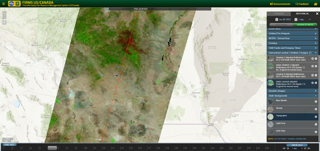
The FIRMS fire map interface can display Landsat orbit tracks for user-selected dates with time of observation. True color and false color Landsat HLS imagery can also be displayed to view with active fire detection data. This display of a June 6, 2022, Landsat 8 acquisition provides the user the coverage provided by a single 185 km Landsat swath.
What is the spatial resolution of the Landsat observations and derived active fire data?
Each hotspot/active fire detection represents the center of a 30 m pixel flagged as containing one or more fires or other thermal anomalies (such as active volcanoes). The “location” is the center point of the pixel (not necessarily the coordinates of the actual fire).
What size of fires can be detected with Landsat?
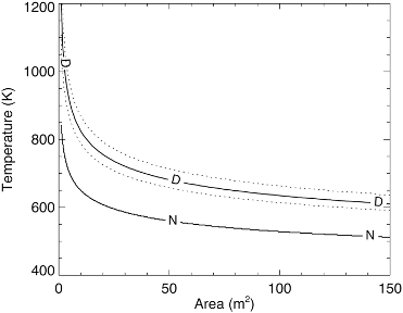
Landsat provides better active fire detection performance compared to coarser spatial resolution sensors, such as MODIS and VIIRS. Flaming fires as small as approximately 4 m2 have a better than 50% chance of detection during the daytime observations. Nighttime detection of similar fire activity improves to an area as small as 1 m2.
Schroeder, W., Oliva, P., Giglio, L., Quayle, B., Lorenz, E., & Morelli, F. (2016). Active fire detection using Landsat-8/OLI data. Remote Sensing of Environment, 185: 210-220. doi:10.1016/j.rse.2015.08.032
Why are Landsat fire data only available for North America?
The Landsat Fire and Thermal Anomalies (LFTA) product is currently produced through a collaboration by USGS EROS Data Center, NASA, and the USDA Forest Service. Daily Landsat 8 and Landsat 9 OLI observations are processed in real-time by EROS and use the NASA-developed algorithm to produce active fire detection data that is ingested into FIRMS. Currently, only Landsat 8 and 9 OLI data collected by the USGS EROS Landsat Ground Station in Sioux Falls, South Dakota, are used to produce active fire detection data. The coverage of the USGS EROS Landsat Ground Station in Sioux Falls is highlighted in the figure below.
Expansion of the geographic coverage for the product is possible through the integration of additional near real-time Landsat 8 and Landsat 9 OLI data from other ground stations. The feasibility of including additional ground stations for North America and elsewhere is currently being investigated.
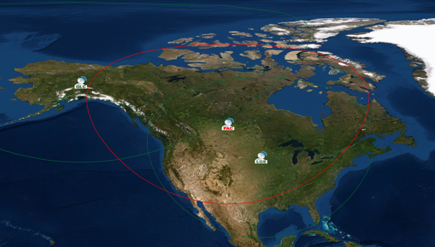
Landsat ground stations for North America. While only the USGS EROS Landsat ground station in Sioux Falls, South Dakota currently produces LFTA data for the area covered by the USGS EROS Landsat Ground Station mask (within the red circle), both the USGS EROS Landsat ground station and the NOAA Gilmore Creek ground station (near Fairbanks, Alaska) collect Landsat 8 and Landsat 9 OLI data. The Canada Centre for Mapping and Earth Observation ground station (Canada) collects Landsat 8 OLI data. Recorded and real-time OLI data from Landsat 8 and Landsat 9 are collected by the EROS and Gilbert Creek ground stations when either satellite is within "line of sight". This condition is achieved when the Landsat orbit passes within the green circles on the map. Near real-time Landsat 8 OLI data can be collected by the Prince Albert ground station in Saskatchewan when Landsat 8 is within its "line of sight" (red circle).
What is the temporal extent of Landsat Active Fire and Thermal Anomalies product in FIRMS?
The temporal extent of Landsat active fire data currently reaches back to June 2022. Processing of earlier acquisitions by Landsat 8 and Landsat 9 is possible, but not planned at this time.
What are the attributes of the Landsat fire data?
The attributes are described in the following table:
| Attribute | Short Description | Long Description |
|---|---|---|
| Satellite | Satellite | L8 = Landsat 8; L9 = Landsat 9 |
| Latitude | Latitude (decimal degrees) | Latitude of pixel center |
| Longitude | Longitude (decimal degrees) | Longitude of pixel center |
| Path | Path | Path number as identified in the World Reference System-2 (WRS-2) |
| Row | Row | Row number as identified in the World Reference System-2 (WRS-2) |
| Track | Track | The pixel location in the along-track dimension of the Landsat path based on the OLI Line-of-Sight (LOS) coordinate system. Generally increases in value from north to south for daytime and nighttime overpasses. |
| Scan | Scan | The pixel location in the cross-track dimension of the Landsat path based on the OLI Line-of-Sight (LOS) coordinate system. Generally increases in value from west to east for daytime and nighttime overpasses. |
| Acquire_Time | Date and time of start of scan | Date and time of acquisition/overpass of the satellite (in UTC). The format is YYYY-MM-DD followed by HH:MM-SS. For example, 2022-07-23 10:09:00. |
| Confidence | Confidence | Value domain: H, M, and L:
|
| Version | Version (FIRMS reference only) | 1.0.7 NRT |
| DayNight | Day or Night | D= Daytime fire, N= Nighttime fire |
What validation of the Landsat fire products has been performed?
Validation of the Landsat active fire product has primarily been performed using available high resolution aerial and commercial satellite imagery, coincident/near coincident 1 km Terra and Aqua MODIS active fire data, and 750 m and 375 m Suomi NPP VIIRS active fire data. A discussion of the validation procedures and results can be found in Schroeder, et al. (2016).
Where can I find more information about the Landsat fire data?
The Landsat active fire detection algorithm is based on the legacy algorithm developed for the Advanced Spaceborne Thermal Emission and Reflection Radiometer (ASTER). Development of the Landsat algorithm was conducted under the auspices of the NASA Applied Sciences Program. Please refer to the following papers by Louis Giglio and Wilfrid Schroder and the NASA Applied Sciences Program project summary for more information on the Landsat active fire algorithm and product.
Schroeder, W., Oliva, P., Giglio, L., Quayle, B., Lorenz, E., & Morelli, F. (2016). Active fire detection using Landsat-8/OLI data. Remote Sensing of Environment, 185: 210-220. doi:10.1016/j.rse.2015.08.032
Giglio, L., Csiszar, I., Restás, Á., Morisette, J. T., Schroeder, W., Morton, D., & Justice, C. O. (2008). Active fire detection and characterization with the advanced spaceborne thermal emission and reflection radiometer (ASTER). Remote Sensing of Environment, 112(6): 3055-3063. doi:10.1016/j.rse.2008.03.003
How does Landsat active fire data compare with MODIS and VIIRS active fire data?
Landsat active fire data are more than 1,000 times more resolute than MODIS and more than 150 times more resolute than VIIRS. The algorithm routinely detects fires as small as a few square meters or smaller, providing spatially explicit detail of the location and extent of fire activity at the time of a satellite overpass. Active fire fronts and scattered smaller fires within the fire perimeter are routinely detected. However, these relatively high spatial resolution data are provided at a lower temporal resolution compared to the daily observation frequency afforded by MODIS and VIIRS. Between both Landsat OLI instruments, areas in the lower to mid latitudes are imaged every 8 days. The temporal resolution of Landsat data can be increased though the collection of nighttime Landsat 8 and Landsat 9 imagery for targeted areas.
The following graphic shows Landsat active fire data compared for MODIS (Terra and Aqua) (1km) and VIIRS (Suomi NPP and NOAA-20) (375m) for the Double Creek Fire in Northeast Oregon on September 10, 2022.
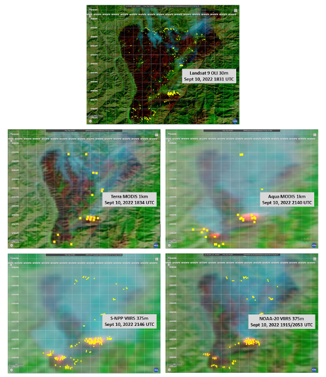
Multi sensor imaging of the Double Creek Fire in Oregon on 10 September 2022. Active fire detections, marked as yellow, derived from Landsat-9/OLI 30 m (displayed on a Landsat 9 HLS surface reflectance image), Terra/MODIS 1 km, Aqua/MODIS 1 km, Suomi NPP/VIIRS 375 m and NOAA-20/VIIRS 375 m (all displayed on respective MODIS and VIIRS corrected reflectance images). Temporal span for these consecutive images is approximately 3 hours.
Why does the latency differ between the Landsat active fire detection data and the HLS Landsat imagery?
Landsat active fire detection data are produced in collaboration with the USGS EROS Data Center in Sioux Falls, South Dakota. Daily Landsat 8 and Landsat 9 OLI imagery for the continental United States, southern Canada, and northern Mexico are captured via the Landsat ground station at EROS. This imagery is formatted and pre-processed in near real-time by the USGS and further processed onsite at EROS using NASA algorithms to extract 30-meter active fire detection data and made available for ingest into FIRMS approximately 30 minutes after a satellite overpass. Landsat imagery in FIRMS is processed as part of the Harmonized Landsat-Sentinel-2 (HLS) project to create BRDF-adjusted, 30-meter Landsat and Sentinel-2 surface reflectance products. Generated separately as provisional/research NASA products, HLS currently has a latency requirement of < 7 days. Consequently, FIRMS users desiring to view Landsat active fire detection data in the context of HLS Landsat true and false color composite imagery are required to wait until the processing of the HLS imagery is complete and made available in FIRMS. The HLS imagery is currently processed and available in FIRMS 2-4 days after acquisition, which is less than the current HLS processing latency requirement. Opportunities to reduce the latency of HLS imagery processing and its availability in FIRMS will continue to be assessed by NASA and implemented if possible.