
The VIIRS pixel footprint size projected onto the Earth increases away from nadir.
VIIRS stands for Visible Infrared Imaging Radiometer Suite (VIIRS). The VIIRS sensor was launched aboard the joint NASA/NOAA Suomi National Polar-orbiting Partnership (Suomi NPP) satellite on October 28th, 2011 and again on the NOAA-20 / Joint Polar Satellite System-1 (JPSS-1) satellite. (Note: JPSS-1 was renamed NOAA-20 after launch).
Suomi NPP crosses the equator at approximately 13:30 PM (ascending node) and 1.30 AM (descending node). NOAA-20 (JPSS-1) leads Suomi NPP by a half orbit so it crosses the equator approximately 50 minutes earlier.
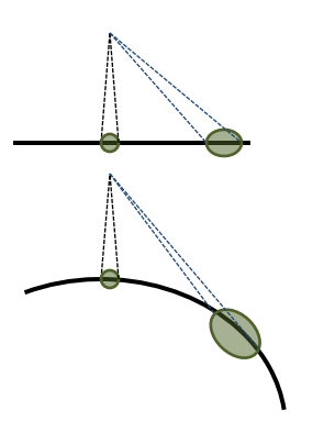
The 3,040 km VIIRS swath enables ~15% image overlap between consecutive orbits at the equator, thereby providing full global coverage every 12 hours and mid-latitudes will experience 3-4 looks a day. VIIRS has 5 high resolution imagery channels (I-bands), 16 moderate resolution channels (M-bands) and a Day/Night Band (DNB). The VIIRS detectors have a constant angular resolution that results in an increasing pixel footprint size as the scan is further from nadir (see figure 1 below). This means the actual area of each scan has the shape of a bow-tie, as consecutive scans overlap away from nadir. The bow-tie effect is reduced during processing through a combination of aggregation and deletion of overlapping pixels.
What VIIRS products are available in LANCE?
The VIIRS I-band (375 m) Active Fire product and Corrected Reflectance imagery are the newest near real-time products available through LANCE. More will follow. The active fire product will be available in FIRMS and images created from these data products, and Corrected Reflectance images are now available through GIBS for viewing using EOSDIS Worldview and similar clients. The new VIIRS images available through GIBS are Corrected Reflectance (True Color; Bands M3, I3, and M11; and Bands M11, I2, and I1) and Fires and Thermal Anomalies (Day/Night).
View Recording of NASA's Earthdata Webinar: Discover NASA's Near Real-Time Data Using LANCE (February 2020)