Amazon Forest Structure from Airborne Lidar, ED2 Initial Condition Files, 2016
This dataset provides initial condition files for initializing the Ecosystem Demography Model (ED2). This dataset holds regional forest structure characteristics across the Brazilian Amazon that were derived from 545 airborne lidar transects (300 x 12500 m each) acquired during the Amazon Biomass Estimation Project (EBA2016) campaign in 2016.

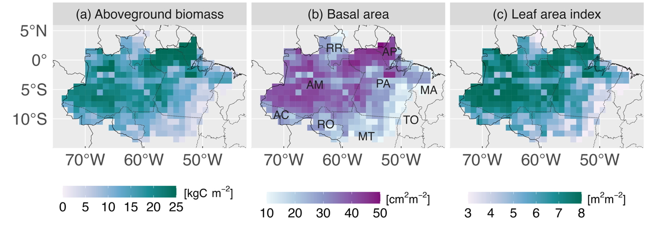
Grid-cell averages of multiple forest structure variables derived from airborne lidar through the approach described in Longo et al. (2020), and used as initial conditions for the Ecosystem Demography Model (ED2): (a) aboveground biomass carbon density, (b) basal area, and (c) leaf area index. Brazilian states overlapping with the Amazon biome indicated in panel (b): Acre (AC), Amapa (AP), Amazonas (AM), Maranhao (MA), Mato Grosso (MT), Para (PA), Rondonia (RO), Roraima (RR), and Tocantins (TO). Source: Longo et al. (2025).
Citation: Longo, M., M.M. Keller, L.M. Kueppers, K.W. Bowman, O. Csillik, A. Ferraz, P.R. Moorcroft, J.P. Ometto, B.S. Soares-Filho, X. Xu, M.L.R. de Assis, E.B. Gorgens, E.J.L. Larson, J.F. Needham, E.M. Ordway, F.R.S. Pereira, E.R. Pinage, L. Sato, L. Xu, and S.S. Saatchi. 2025. Amazon Forest Structure from Airborne Lidar, ED2 Initial Condition Files, 2016. ORNL DAAC, Oak Ridge, Tennessee, USA. https://doi.org/10.3334/ORNLDAAC/2412
