Page 1 of 1
Choosing MAIAC VIIRS tiles to cover a region
Posted: Tue Apr 21, 2026 10:15 am America/New_York
by kodiologist
Similar to my previous question about MODIS (
viewtopic.php?p=13437 ), I want to find the tile identifiers for VJ119A2 and VNP19A2 to cover a region of interest, such as the contiguous United States. The tile structure is depicted visually in Figure 1b of the user guide (
https://lpdaac.usgs.gov/documents/2268/VNP19_User_Guide_V1.pdf ), but is there a geometry file for it?
Re: Choosing MAIAC VIIRS tiles to cover a region
Posted: Wed Apr 22, 2026 8:46 am America/New_York
by LP DAAC - lien
Hello,
The LPDAAC does not have spatial geometry files, however I believe this USGS site may be able to help, it looks like they have .shp files available for CONUS, Alaska, and Australia:
https://www.sciencebase.gov/catalog/item/623a013ed34e915b67cddcfa
Please let us know if you have any questions.
Thanks,
Brett
Re: Choosing MAIAC VIIRS tiles to cover a region
Posted: Thu Apr 23, 2026 5:21 pm America/New_York
by LP DAAC - dgolon
@kodiologist VIIRS uses the same HV tile grid as MODIS. If you search "MODIS HV Grid Shapefile" in a search engine a kml/kmz of the MODIS grid from ORNL DAAC should show up in the results. I tried to upload it to the forum, but it wasn't accepting the file format. If you can't find it, email us at
lpdaac@usgs.gov and mention Danielle in your email and I'll send it to you there. Thanks -- Danielle
Re: Choosing MAIAC VIIRS tiles to cover a region
Posted: Fri Apr 24, 2026 7:47 am America/New_York
by kodiologist
VIIRS uses the same HV tile grid as MODIS.
That's what is also claimed on this page (
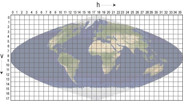
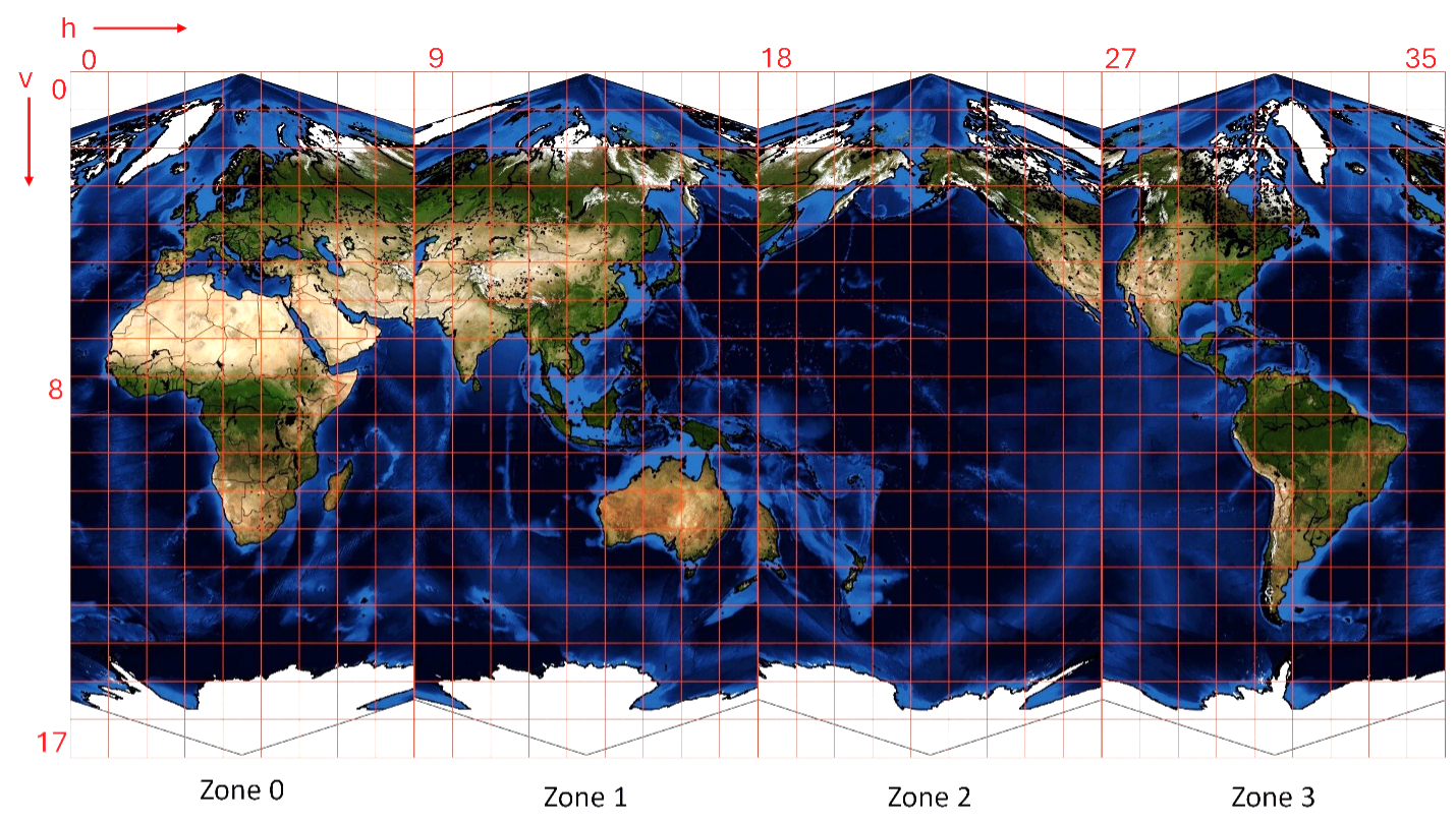
https://www.earthdata.nasa.gov/data/instruments/viirs ), but if you look at the figures, the relationships between the tile identifiers and geography are pretty different:
https://earthdata.nasa.gov/s3fs-public/2025-03/modis_sinusoidal_grid.width-800.jpg
https://earthdata.nasa.gov/s3fs-public/2026-01/viirs-zsp.png
For example, in the MODIS system, California is around h08, but in the VIIRS system, it's around h27. From the CRS and extent information in HDF5 VIIRS data files I've looked at, it appears to be the VIIRS figure that's correct.
Re: Choosing MAIAC VIIRS tiles to cover a region
Posted: Fri Apr 24, 2026 9:57 am America/New_York
by LP DAAC - dgolon
@kodiologist Ah yes, apologies. The VIIRS MAIAC (19s) products do indeed follow a different grid. I'll see about getting the information updated on the website to make that a little clearer. I don't believe we have a shapefile or kmz for the MAIAC VIIRS Zonal Sinusoidal Projection (ZSP). However, I have a few messages out to see if one does exist. I'll let you know if I find one.
Re: Choosing MAIAC VIIRS tiles to cover a region
Posted: Thu Apr 30, 2026 9:39 am America/New_York
by LP DAAC - dgolon
@kodiologist We have heard back from the Science Team. They do not have a shapefile that can be directly used in GIS. However, they have the corner coordinates for every tile, in case that is helpful. The forum is not allowing me to upload the CSV they sent us but if you email in to our team (
lpdaac@usgs.gov) we can send it to you. In the meantime, they also have the lat-long for every pixel, which you can find here:
https://portal.nccs.nasa.gov/datashare/maiac/DataRelease/VIIRS_latlon_750m/ Thanks -- Danielle
Re: Choosing MAIAC VIIRS tiles to cover a region
Posted: Thu May 07, 2026 9:03 am America/New_York
by kodiologist
The forum only restricts attachments by file name, not contents, so I just added a bogus ".pdf" extension and it let me upload the file:
Re: Choosing MAIAC VIIRS tiles to cover a region
Posted: Thu May 07, 2026 9:08 am America/New_York
by LP DAAC - dgolon
Thanks, @kodiologist Our team is also working on getting a copy uploaded to the website. Once it is live I'll add the link here.
Re: Choosing MAIAC VIIRS tiles to cover a region
Posted: Wed May 13, 2026 2:24 pm America/New_York
by LP DAAC - dgolon
For those looking for the CSV in the future, it has been added under the Documents and Resources sections of the Dataset Landing Pages. i.e.
https://doi.org/10.5067/VIIRS/VJ119A2.002 and it can also now be found under the VIIRS Tiling Systems section here:
https://www.earthdata.nasa.gov/data/instruments/viirs Thanks -- Danielle